 |
|
     |
|
Other Brandy Bottom PagesAs well as an introductory page, the other Brandy Bottom pages cover the history, and the AIBT's conservation work at the site. The latter is divided into several sections: a summary of the progress at work parties, together with pages of photos of the buildings, work parties, finds and nature. There are also images of the display boards. Brandy Bottom: Heritage Open Days - September 2025Brandy Bottom will be open on Saturday 13 and Sunday 14 September as part of the 2025 Heritage Open Days (HODs). Come and visit the best a well-preserved 19th Century Coalmine site. We will take you on a tour and show you the work of our volunteers in exploring the Industrial Archaeology and conserving the structure of this historically important Scheduled Monument. First tour starts at 10.30 am and the last at 3.30 pm on both days. Tours take around 45-60 minutes. Refreshments available, donations very welcome. This is a working site, with rough paths, steps, and slopes, some of which are steep. As a result many areas are not accessible to wheelchair users or prams. Stout footwear should be worn. Children must be accompanied by a responsible adult. Highway parking is limited at Coxgrove Hill but there is easy access on foot/ by cycling using the cycle path. There will be a cycle park inside the perimeter fence on the day. Location Map
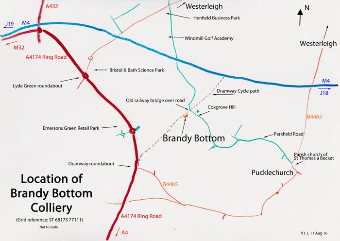
DirectionsBrandy Bottom is located on the Avon cycle path, 400 yards to the south of where the path crosses over Coxgrove Hill. The Grid reference is: ST 68175 77111, while the what3words reference is: wisely.amber.rarely. Turn off the A4174 Ring Road at the Lyde Green roundabout, taking the road to Westerleigh. At the next roundabout take the second out, again following the signs for Westerleigh. About 1 mile after crossing over the M4 motorway, turn right onto Henfield Road, marked by signs for the 'Henfield Business Park' and the 'Windmill Golf Academy'. About 500 yards after passing under the motorway, the road turns sharply right. After another 300 yards there is another sharp turn, this time to the left with a road sign marked 'Coxgrove Road' on the outside of the bend. There is a stone bridge over the road 100 yards beyond the bend. Car parking is limited to the road verges on either side of the bridge. After leaving the car parking area, take the sloping path up to the cycleway, and turn left at the top away from the bridge. It is about 100 yards to a ruined platelayers hut, where you continue on the tarmac path between the two halves of a mine winding wheel. Brandy Bottom is located on the left of the path a further 100 yards on from the wheel. A downloadable copy of the location map and directions can be obtained by clicking on this link. Other Brandy Bottom PagesAs well as an introductory page, the other Brandy Bottom pages cover the history, and the AIBT's conservation work at the site. The latter is divided into several sections: a summary of the progress at work parties, together with pages of photos of the buildings, work parties, finds and nature. There are also images of the display boards. Page updated 10 Aug 25 |
|
| [email protected] | |